The Friends of Hunmanby Railway Station is an active community group keen to promote travel by rail and the local economy. Over 15 years the village station has been transformed into a ‘gateway’ to the village ‘betwixt Wolds & Sea’ with approaching 100 flower planters and four beautiful flower borders totalling over 350 feet.
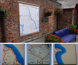
In the Edwardian era, over 110 years ago, the North Eastern Railway erected at least two dozen tile maps across its network. Amazingly half still exist, two being on the Scarborough to Hull railway line at Beverley and Scarborough. In August 2021 the first North Eastern Railway Tile Map in over 100 years was put up at the station on the National Rail network, at Hunmanby!
In Spring 2022, for the 175th Anniversary of the opening of the Hull to Scarborough Railway Line (1847-2022) the Friends group produced (at their own cost) a short guide to railway maps and artefacts along the Yorkshire Wolds Coast Line.
The leaflet was an uplifting story of generosity and community spirit aiming to inspire visits to the local line. With plenty of illustrations, it made seeking out history and geography interesting. All the locations described were free to view and promoted the involvement of station staff and local communities who have enhanced their stations. It was produced as the country emerged into the ‘new normal’ following the pandemic, and it aimed to promote short days out and highlight items of railway history that are often overlooked. The leaflet was delivered by volunteers to 150 premises within walking distance of stations on the Yorkshire Wolds Coastline: local shops, hair salons, public houses, and schools.
The Yorkshire Wolds Coast Historic Railway Map Trail leaflet was a victim of its own success. It proved so popular that copies ran out within a couple of weeks. The timing was arranged as the railway network in the north started promoting travel by train with the ‘do your own thing’ campaign. In early Spring, many people were still cautious about using public transport. The Historic Railway Map Trail leaflet was targeted at communities close to stations on the Yorkshire Wolds Coastline, especially between Hull and Driffield, where people may well be tempted on a short trip out to the coast by train.
Friends of Hunmanby Railway Station approached the BID to get it reprinted and distributed more widely. It will now be distributed by volunteers across the region to art galleries, historic buildings, leisure centres, museums, and redeveloped heritage buildings housing family-run businesses. All places where this historic leaflet trail will be of interest and help to generate visitors to the Yorkshire Coast, especially by train.
Further details of the North Eastern Railway Tile Map at Hunmanby: North Eastern Railway Tile Map – Friends of Hunmanby Railway Station (e-voice.org.uk)